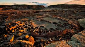
The Grand Canyon, Wupatki National Monument and Sunset Crater Volcano are some of the geologic and cultural gems of the National Park Service. This summer, KNAU's Earth Notes series will highlight these, and other special places across the Southwest in honor of the Park Service's 100th anniversary. In the second installment of the series, we hear about how Wupatki's population survived there a thousand years ago despite the area's extreme arid environment.
The region around Wupatki National Monument on the San Francisco Plateau is so dry it was called the Sierra Sin Agua, or “Mountains Without Water,” by early Spanish explorers. Yet from the 11th to 13th centuries this region supported a population of between several hundred and 2,000 people. How did they do it?
In cooperation with the National Park Service, researchers from Northern Arizona University’s anthropology department have used modern mapping and modeling to study what remains of ancient infrastructure. They’ve found that a series of constructed wet weather storage ponds were a key component of water management by the farmers here.

They built dams with embankments to shield against prevailing winds, and mounds to slow runoff and retain soil moisture. Researchers estimate that one catchment could collect enough water to supply nine people with a gallon of drinking water a day for a month – or irrigate two acres of corn or beans for a day.
But during dry months water had to be found from other sources to sustain the farming and domestic water needs of hundreds of people. So water from snowmelt and rain runoff was stored in large ceramic jars – and people also walked up to eight miles to collect water from the Little Colorado River.
The Wupatki population decreased dramatically after four significant droughts hit the region. It may not have been a simple lack of water that made these efficient people leave in the end, though, but a prolonged spell of colder weather.


